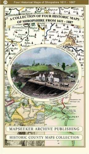
A Shropshire 1611 - 1836 - Fold Up Map that features a collection of Four Historic Maps, John Speed's County Map 1611, Johan Blaeu's County Map of 1648, Thomas Moules County Map of 1836 and a Map of the Severn Valley Railway in 1887.The maps also feature a number of early views across Shropshire including the famous Ironbridge over the Severn and the Severn at Bridgnorth.: Historic English Counties Maps Collection
Autor Mapseeker Publishing Ltd Mapseeker Publishing Ltden Limba Engleză Paperback – 2019
Preț: 132.31 lei
Nou
Puncte Express: 198
Preț estimativ în valută:
25.33€ • 27.52$ • 21.29£
25.33€ • 27.52$ • 21.29£
Carte disponibilă
Livrare economică 31 martie-14 aprilie
Livrare express 15-21 martie pentru 14.20 lei
Preluare comenzi: 021 569.72.76
Specificații
ISBN-13: 9781844918447
ISBN-10: 1844918440
Pagini: 1
Ilustrații: Historic Map Images
Dimensiuni: 228 x 139 x 55 mm
Greutate: 0.1 kg
Editura: Historical Images Ltd
Colecția Historic English Counties Maps Collection
Seria Historic English Counties Maps Collection
ISBN-10: 1844918440
Pagini: 1
Ilustrații: Historic Map Images
Dimensiuni: 228 x 139 x 55 mm
Greutate: 0.1 kg
Editura: Historical Images Ltd
Colecția Historic English Counties Maps Collection
Seria Historic English Counties Maps Collection