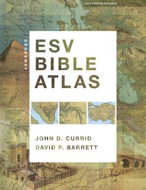
Crossway ESV Bible Atlas
Autor John D. Currid, David P. Barretten Limba Engleză Hardback – 9 iun 2010
Vezi toate premiile Carte premiată
Christian Book Award (2011)
All the key methods of presenting Bible geography and history are here, including more than 175 full-color maps, 70 photographs, 3-D re-creations of biblical objects and sites, indexes, timelines, and 65,000 words of narrative description. The atlas uniquely features regional maps detailing biblically significant areas such as Egypt, Mesopotamia, Italy, and Greece. It also includes access to online maps and illustrations and a removable, 16.5 x 22-inch map of Palestine.
This carefully crafted reference tool not only sets a new standard in Bible atlases but will help ESV readers more clearly understand the world of the Bible and the meaning of Scripture.
Preț: 300.74 lei
Nou
Puncte Express: 451
Preț estimativ în valută:
57.56€ • 62.55$ • 48.39£
57.56€ • 62.55$ • 48.39£
Carte disponibilă
Livrare economică 01-15 aprilie
Livrare express 15-21 martie pentru 118.87 lei
Preluare comenzi: 021 569.72.76
Specificații
ISBN-13: 9781433501920
ISBN-10: 1433501929
Pagini: 352
Ilustrații: maps
Dimensiuni: 239 x 307 x 38 mm
Greutate: 2.36 kg
Editura: SPCK – Crossway
ISBN-10: 1433501929
Pagini: 352
Ilustrații: maps
Dimensiuni: 239 x 307 x 38 mm
Greutate: 2.36 kg
Editura: SPCK – Crossway
V-ar putea interesa
-
 The Gospel of Ruth: Loving God Enough to Break the RulesCarolyn Custis JamesPreț: 70.05 lei
 -
 Lies, Sex and PoliticiansJohn HoldsworthPreț: 148.02 lei
 -
 Legal Revision and Religious Renewal in Ancient IsraelBernard M. LevinsonPreț: 331.85 lei
 -
 Life AttitudesROBERT WARRENPreț: 40.99 lei
 -
 Out of BabylonWalter BrueggemannPreț: 97.69 lei
 -
 ESV Study Bible (Hardcover)T. Desmond AlexanderPreț: 295.22 lei
 -
 Preț: 118.25 lei
 -
 ESV Study Bible, Large Print (Hardcover)T. Desmond Alexander-8%Preț: 356.25 lei387.23 lei
Descriere
Capitalizing on recent advances in satellite imaging and geographic information systems, the Crossway ESV Bible Atlas offers Bible readers a comprehensive, up-to-date resource that blends technical sophistication with readability, visual appeal, and historical and biblical accuracy.
All the key methods of presenting Bible geography and history are here, including more than 175 full-color maps, 70 photographs, 3-D re-creations of biblical objects and sites, indexes, timelines, and 65,000 words of narrative description. The atlas uniquely features regional maps detailing biblically significant areas such as Egypt, Mesopotamia, Italy, and Greece. It also includes a CD with searchable indexes and digital maps, and a removable, 16.5 x 22-inch map of Palestine.
This carefully crafted reference tool not only sets a new standard in Bible atlases but will help ESV readers more clearly understand the world of the Bible and the meaning of Scripture.
Notă biografică
Premii
- Christian Book Award Finalist, 2011