Cantitate/Preț
Produs

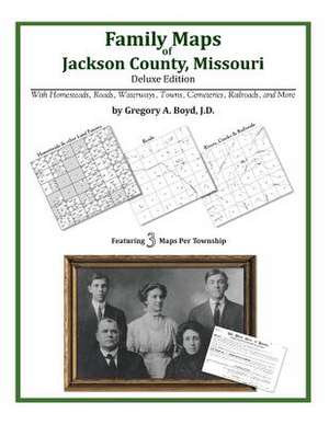
Family Maps of Jackson County, Missouri

Autor Gregory a. Boyd J. D.
en Limba Engleză Paperback
274 pages with 71 total maps Locating original landowners in maps has never been an easy task-until now. This volume in the Family Maps series contains newly created maps of original landowners (patent maps) in what is now Jackson County, Missouri, gleaned from the indexes of the U.S. Bureau of Land Management. But it offers much more than that. For each township in the county, there are two additional maps accompanying the patent map: a road map and a map showing waterways, railroads, and both modern and many historical city-centers and cemeteries. Included are indexes to help you locate what you are looking for, whether you know a person's name, a last name, a place-name, or a cemetery. The combination of maps and indexes are designed to aid researchers of American history or genealogy to explore frontier neighborhoods, examine family migrations, locate hard-to-find cemeteries and towns, as well as locate land based on legal descriptions found in old documents or deeds. The patent-maps are essentially plat maps but instead of depicting owners for a particular year, these maps show original landowners, no matter when the transfer from the federal government was completed. Dates of patents typically begin near the time of statehood and run into the early 1900s. What's Mapped in this book (that you'll not likely find elsewhere) . . . 4653 Parcels of Land (with original landowner names and patent-dates labeled in the relevant map) 70 Cemeteries plus . . . Roads, and existing Rivers, Creeks, Streams, Railroads, and Small-towns (including some historical), etc. What YEARS are these maps for? Here are the counts for parcels of land mapped, by the decade in which the corresponding land patents were issued: DecadeParcel-count 1820s104 1830s1787 1840s1577 1850s1106 1860s45 1870s7 1880s4 1890s9 1900s6 1910s3 1920s5 What Cities and Towns are in Jackson County, Missouri (and in this book)? Adams, Air Line Junction, Atherton, Athol, Belvidere, Blue Mills, Blue Springs, Bristol, Bryant, Buckner, Cement City, Centropolis, Cobbler, Cockrell, Courtney, Dallas, Dodson, East Independence, Eastwood, Englewood, Eton, Fairmount, Flinn, Grain Valley, Grandview, Greenwood, Hickman Mills, Hicks City, Hiler, Holmes Park, Independence, Indian Village, Jeffreys, Kansas City, Knobtown, Lake City, Lake Lotawana, Lake Tapawingo, Leeds, Lees Summit, Levasy, Little Blue, Lone Jack, Longview, Manchester School, Marlborough, Martin City, Maywood, Melville, Mount Washington, New Santa Fe, Oak Grove, Pink Hill, Raytown, Red Bridge, Ripley, River Bend, Rock Creek Junction, Ruskin, Ruskin Heights, Selsa, Sibley, Sni Mills, South Lee, Sugar Creek, Tarsney, Tarsney Lakes, Truman Corners, Union Point, Unity Village, Vale, Waldo, Westport
Citește tot Restrânge

Preț: 23045 lei

Nou

Puncte Express: 346

Preț estimativ în valută:
4410 4595$ 3667£

Carte disponibilă

Livrare economică 18 ianuarie-01 februarie 25

Preluare comenzi: 021 569.72.76

Specificații

ISBN-13: 9781420311440
ISBN-10: 1420311441
Pagini: 286
Dimensiuni: 216 x 279 x 15 mm
Greutate: 0.67 kg
Editura: Arphax Publishing Co.