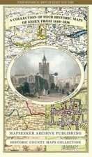
Essex 1610 - 1836 - Fold Up Map that features a collection of Four Historic Maps, John Speed's County Map 1610, Johan Blaeu's County Map of 1648, Thomas Moules County Map of 1836 and a Plan of Colchester 1805 by Cole and Roper.
18 noi 2014
Sheet map
Preț: 132.35 lei
3-5 săpt. | 10-14 zile