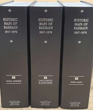
Historic Maps of Bahrain 1817–1970 3 Volumes Hardback Set: Cambridge Archive Editions
Editat de R. Jarmanen Limba Engleză Quantity pack – 26 aug 2020
Din seria Cambridge Archive Editions
- 14%
 Preț: 9690.38 lei
 - 23%
 Preț: 10221.40 lei
 - 9%
 Preț: 27992.57 lei
 - 15%
 Preț: 451.71 lei
 - 15%
 Preț: 19202.36 lei
 - 16%
 Preț: 2360.93 lei
 - 15%
 Preț: 28131.09 lei
 - 16%
 Preț: 32942.30 lei
 - 23%
 Preț: 24164.99 lei
 - 9%
 Preț: 32947.26 lei
 - 14%
 Preț: 14475.01 lei
 - 15%
 Preț: 4721.72 lei
 - 16%
 Preț: 28255.35 lei
 - 16%
 Preț: 70571.17 lei
 - 16%
 Preț: 2376.03 lei
 - 9%
 Preț: 11772.77 lei
 - 16%
 Preț: 9415.01 lei
 - 15%
 Preț: 23575.29 lei
 - 17%
 Preț: 4729.27 lei
 - 23%
 Preț: 25521.53 lei
 - 9%
 Preț: 14166.66 lei
 - 17%
 Preț: 55968.71 lei
 - 16%
 Preț: 14155.11 lei
 - 15%
 Preț: 18900.51 lei
 - 15%
 Preț: 16504.95 lei
 - 9%
 Preț: 14154.11 lei
 - 16%
 Preț: 21184.65 lei
 - 16%
 Preț: 7057.72 lei
 - 16%
 Preț: 18859.35 lei
 - 16%
 Preț: 32990.93 lei
 - 16%
 Preț: 11775.81 lei
 - 16%
 Preț: 9467.88 lei
 - 17%
 Preț: 11746.35 lei
 - 16%
 Preț: 5200.45 lei
 - 14%
 Preț: 36166.35 lei
 - 17%
 Preț: 37485.18 lei
 - 15%
 Preț: 47310.74 lei
 - 9%
 Preț: 14157.68 lei
 - 23%
 Preț: 35373.00 lei
 - 16%
 Preț: 14127.91 lei
 - 15%
 Preț: 18820.45 lei
 - 16%
 Preț: 14123.51 lei
 - 16%
 Preț: 28306.70 lei
 - 9%
 Preț: 14158.13 lei
 - 16%
 Preț: 21211.46 lei
 - 16%
 Preț: 18833.67 lei
 - 9%
 Preț: 42523.41 lei
 - 16%
 Preț: 4727.68 lei
 - 23%
 Preț: 10053.39 lei
 - 17%
 Preț: 23349.44 lei
Preț: 7053.73 lei
Preț vechi: 8447.54 lei
-16% Nou
Puncte Express: 10581
Preț estimativ în valută:
1349.86€ • 1400.75$ • 1128.27£
1349.86€ • 1400.75$ • 1128.27£
Carte indisponibilă temporar
Doresc să fiu notificat când acest titlu va fi disponibil:
Se trimite...
Preluare comenzi: 021 569.72.76
Specificații
ISBN-13: 9781788060790
ISBN-10: 1788060792
Pagini: 56
Dimensiuni: 202 x 275 x 230 mm
Greutate: 3.3 kg
Editura: Cambridge University Press
Colecția Cambridge University Press
Seria Cambridge Archive Editions
Locul publicării:Cambridge, United Kingdom
ISBN-10: 1788060792
Pagini: 56
Dimensiuni: 202 x 275 x 230 mm
Greutate: 3.3 kg
Editura: Cambridge University Press
Colecția Cambridge University Press
Seria Cambridge Archive Editions
Locul publicării:Cambridge, United Kingdom
Cuprins
Naval Surveys 1817–1937; Land Surveys of Bahrain 1904–1969; Town Maps: Manama City and Suburbs 1926–1956; Manama City and Suburbs 1957–1970; Muharraq Town and Island 1931–1970; Awali 1957–1963.
Descriere
This map collection is important for its diverse sources, making available maps previously private, unknown or inaccessible.
