
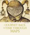
Historical Sea Charts: Through the Ages
Autor Katherine Parkeren Limba Engleză Hardback – 16 oct 2023


Preț: 230.72 lei
Nou
Puncte Express: 346
Preț estimativ în valută:
44.15€ • 47.94$ • 37.09£
44.15€ • 47.94$ • 37.09£
Carte disponibilă
Livrare economică 02-16 aprilie
Livrare express 18-22 martie pentru 85.72 lei
Preluare comenzi: 021 569.72.76
Specificații
ISBN-13: 9788854417168
ISBN-10: 8854417165
Pagini: 208
Ilustrații: Fully illustrated
Dimensiuni: 272 x 313 x 28 mm
Greutate: 1.72 kg
Editura: White Star
Seria Through the Ages
ISBN-10: 8854417165
Pagini: 208
Ilustrații: Fully illustrated
Dimensiuni: 272 x 313 x 28 mm
Greutate: 1.72 kg
Editura: White Star
Seria Through the Ages
Notă biografică
Katherine Parker, fellowship of the Royal Geographical Society, is the Research Officer at Barry Lawrence Ruderman Antique Maps Inc. She received her PhD in History from the University of Pittsburgh in 2016. She has published in an array of scholarly journals and edited collections. Barry Lawrence Ruderman is the owner of Barry Lawrence Ruderman Antique Maps Inc. (RareMaps.com). Founded in 1992, the firm is the largest online antique map dealer in the world, with over 10,000 maps, charts, city plans, and atlases. The site also features a research archive of over 60,000 online images and descriptions. Barry Ruderman is one of the founding friends of the David Rumsey Map Center at Stanford University and the sponsor of the Barry Lawrence Ruderman Conference on Cartography held there biennially. He is the author or co-author of a number of articles on antique maps and the antique map trade.
Descriere
This book shows the history of charts and nautical maps from the earliest known examples to the one used in the Twentieth Century, with a special focus on the map makers and the methods of use from 1300 to 1900.