Interactions between Land Use and Flood Management in the Chi River Basin: UNESCO-IHE PhD Thesis
Autor Kittiwet Kuntiyawichaien Limba Engleză Paperback – 11 mai 2012
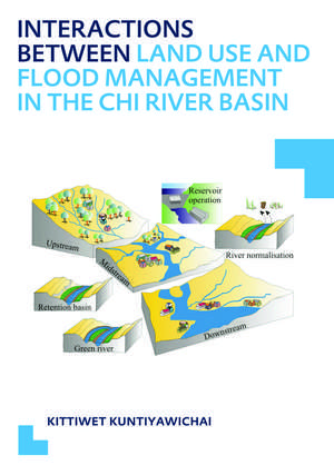
The Chi River system cannot handle the regularly occurring floods, consequently, flooding of the low-lying areas occurs on a regular basis. Therefore, an integrated flood management framework needs to be developed to minimize the negative effects of floods of different magnitude. In response, a hydrological model (SWAT) and a hydraulic (1D/2D SOBEK) model were integrated to simulate floods in detailed way and to analyse the current system. A reliable simulation of the river flows and inundated areas is an essential component of a holistic flood management plan.
The developed modelling framework enabled to analyse the impact of different structural measures such as river normalisation, green river (bypass), and retention basin. In addition, non-structural measures including reservoir operation and spatial land use planning were assessed in their capability to protect people and valuable infrastructure. For each measure, several possible scenarios were tested and evaluated based on economic and technical efficiency criteria to determine the most promising and efficient scenario. However, effective interventions may involve a judicious combination of flood mitigation approaches, rather than reliance on a stand-alone solution. A truly optimum combination of aforesaid measures was then chosen since it could considerably reduce flood extent and its damage.
Finally, the study illustrates the effects of land use changes on floods, which indicated little or no significant potential impact on flood regime at river basin level, but rather at sub-basin scale. This finding is important for a better understanding of the scale and direction of impacts of developments in the future. Integrated land use planning was shown to be an essential component of a comprehensive flood management framework.
Preț: 496.53 lei
Preț vechi: 665.37 lei
-25% Nou
Puncte Express: 745
Preț estimativ în valută:
95.04€ • 97.94$ • 80.23£
95.04€ • 97.94$ • 80.23£
Carte tipărită la comandă
Livrare economică 03-17 martie
Preluare comenzi: 021 569.72.76
Specificații
ISBN-13: 9780415631242
ISBN-10: 0415631246
Pagini: 240
Dimensiuni: 174 x 246 x 13 mm
Greutate: 0.43 kg
Ediția:1
Editura: CRC Press
Colecția CRC Press
ISBN-10: 0415631246
Pagini: 240
Dimensiuni: 174 x 246 x 13 mm
Greutate: 0.43 kg
Ediția:1
Editura: CRC Press
Colecția CRC Press
V-ar putea interesa
-
 Mathematics and the Image of ReasonMary TilesPreț: 459.71 lei
 -
 Preț: 380.31 lei
 -
 Recurrence in Ergodic Theory and Combinatorial Number TheoryHarry Furstenberg-19%Preț: 706.02 lei871.63 lei
 -
 An Introduction to Combinatorial AnalysisJohn Riordan-23%Preț: 782.75 lei1016.56 lei
 -
 Problem Posing: Reflections and ApplicationsStephen I. Brown-47%Preț: 245.13 lei461.39 lei
 -
 Counting on GOD!Coretta WrenPreț: 43.45 lei
 -
 Preț: 151.42 lei
 -
 -18%Preț: 1118.65 lei1364.20 lei
 -
 -26%Preț: 1042.56 lei1404.21 lei
 -
 Preț: 384.86 lei
 -
 -23%Preț: 1244.93 lei1616.80 lei
 -
 -22%Preț: 1444.32 lei1853.13 lei
 -
 Building Support for Scholarly Practices in Mathematics MethodsSigne E. KastbergPreț: 397.07 lei
 -
 -15%Preț: 693.38 lei815.73 lei
 -
 MATHEMATICAL BIOLOGY AND BIOLOGICAL PHYSICSRubem P Mondaini-18%Preț: 780.26 lei951.53 lei
Public țintă
PostgraduateCuprins
1. Introduction
2. Background
3. Water resources and land use pattern in the Chi River Basin
4. Impact assessment of land use on flooding conditions
5. Mathematical modelling
6. Application of mathematical models for flood investigations
7. Implications for future flood management actions in the Chi River Basin
8. Evaluation
Notă biografică
Kittiwet Kuntiyawichai (1977, Buriram, Thailand) received a BEng degree in Transportation Engineering from Suranaree University of Technology in Thailand (1999) and worked as lecturer in the Department of Civil Engineering, Buriram Technical College.
In 2004 he received his Master’s degree in Water Resources Engineering at the Department of Civil Engineering, Faculty of Engineering, Khon Kaen University, Thailand, with the thesis entitled ‘An application of INFOWORKS RS model for flood routing in Chi River Basin’.
In 2005, he joined the Hydraulic Engineering - Land and Water Development (HELWD) Core, Department of Water Engineering, UNESCO-IHE Institute for Water Education, Delft, the Netherlands, for his PhD study.
Descriere
The study illustrates the effects of land use changes on floods, which indicated little or no significant potential impact on flood regime at river basin level, but rather at sub-basin scale. This finding is important for a better understanding of the scale and direction of impacts of developments in the future. Integrated land use planning was shown to be an essential component of a comprehensive flood management framework.