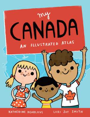
My Canada: An Illustrated Atlas
Autor Katherine Dearlove Ilustrat de Lori Joy Smithen Limba Engleză Hardback – 9 mai 2017 – vârsta de la 4 până la 8 ani
This picture book atlas of Canada is a whimsical, informative introduction to our country from sea to sea to sea. Each province and territory is featured on its own spread, with icons and labels indicating the capital city, other major cities, key lakes and rivers, iconic landmarks, animals, and plants, significant national and provincial parks, and more.
Each map is lively and colorful with plenty of details to discover. Simple labels make key places and landmarks easily searchable for further research. Inspired by the illustrator’s map of PEI, a longtime gift shop bestseller, My Canada includes basic information about Canada and a full map of the country. It’s an excellent resource for celebrating Canada’s sesquicentennial.
Each map is lively and colorful with plenty of details to discover. Simple labels make key places and landmarks easily searchable for further research. Inspired by the illustrator’s map of PEI, a longtime gift shop bestseller, My Canada includes basic information about Canada and a full map of the country. It’s an excellent resource for celebrating Canada’s sesquicentennial.
Preț: 109.20 lei
Nou
Puncte Express: 164
Preț estimativ în valută:
20.89€ • 21.87$ • 17.29£
20.89€ • 21.87$ • 17.29£
Carte indisponibilă temporar
Doresc să fiu notificat când acest titlu va fi disponibil:
Se trimite...
Preluare comenzi: 021 569.72.76
Specificații
ISBN-13: 9781771472647
ISBN-10: 1771472642
Pagini: 32
Ilustrații: Color illustrations throughout
Dimensiuni: 216 x 279 mm
Greutate: 0.45 kg
Editura: Owlkids Books
Colecția Owlkids Books
ISBN-10: 1771472642
Pagini: 32
Ilustrații: Color illustrations throughout
Dimensiuni: 216 x 279 mm
Greutate: 0.45 kg
Editura: Owlkids Books
Colecția Owlkids Books
