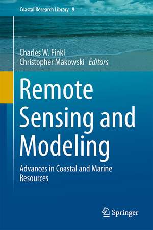
Remote Sensing and Modeling: Advances in Coastal and Marine Resources: Coastal Research Library, cartea 9
Editat de Charles W. Finkl, Christopher Makowskien Limba Engleză Hardback – 12 sep 2014
Din seria Coastal Research Library
- 18%
 Preț: 809.07 lei
 - 15%
 Preț: 646.62 lei
 - 15%
 Preț: 654.12 lei
 - 18%
 Preț: 968.65 lei
 - 18%
 Preț: 1249.93 lei
 -
 Preț: 395.47 lei
 - 20%
 Preț: 757.61 lei
 - 18%
 Preț: 1417.72 lei
 - 18%
 Preț: 726.37 lei
 - 18%
 Preț: 971.01 lei
 - 18%
 Preț: 985.24 lei
 - 15%
 Preț: 641.71 lei
 - 15%
 Preț: 644.30 lei
 - 15%
 Preț: 643.84 lei
 - 15%
 Preț: 649.54 lei
 - 20%
 Preț: 572.08 lei
 - 24%
 Preț: 809.92 lei
 - 24%
 Preț: 698.81 lei
 - 24%
 Preț: 840.67 lei
 - 24%
 Preț: 825.71 lei
 - 24%
 Preț: 1257.50 lei
 - 24%
 Preț: 819.28 lei
 - 24%
 Preț: 1518.88 lei
 - 23%
 Preț: 1377.39 lei
 - 20%
 Preț: 608.35 lei
 - 24%
 Preț: 763.00 lei
 - 15%
 Preț: 699.28 lei
 - 20%
 Preț: 624.68 lei
 -
 Preț: 400.03 lei
 - 20%
 Preț: 552.36 lei
 - 24%
 Preț: 671.00 lei
 -
 Preț: 412.27 lei
Preț: 969.44 lei
Preț vechi: 1182.25 lei
-18% Nou
Puncte Express: 1454
Preț estimativ în valută:
185.50€ • 194.17$ • 154.40£
185.50€ • 194.17$ • 154.40£
Carte tipărită la comandă
Livrare economică 31 martie-14 aprilie
Preluare comenzi: 021 569.72.76
Specificații
ISBN-13: 9783319063256
ISBN-10: 3319063251
Pagini: 502
Ilustrații: XX, 502 p. 208 illus., 151 illus. in color.
Dimensiuni: 155 x 235 x 27 mm
Greutate: 1.13 kg
Ediția:2014
Editura: Springer International Publishing
Colecția Springer
Seria Coastal Research Library
Locul publicării:Cham, Switzerland
ISBN-10: 3319063251
Pagini: 502
Ilustrații: XX, 502 p. 208 illus., 151 illus. in color.
Dimensiuni: 155 x 235 x 27 mm
Greutate: 1.13 kg
Ediția:2014
Editura: Springer International Publishing
Colecția Springer
Seria Coastal Research Library
Locul publicării:Cham, Switzerland
Public țintă
ResearchCuprins
Part I Remote Sensing, Mapping and Survey of Coastal Biophysical Environments.- Remote Sensing of Coastal Ecosystems and Environments.- Advanced Techniques for Mapping Biophysical Environments on Carbonate Banks Using Laser Airborne Depth Sounding (LADS) and IKONOS Satellite Imagery.- Terrestrial Laser Scanner Surveying in Coastal Settings.- Advances in Applied Remote Sensing to Coastal Environments Using Free Satellite Imagery.- Remote Sensing and Modeling of Coral Reef Resilience.- An Assessment of Physiographic Habitats, Geomorphology and Evolution of Chilika Lagoon (Odisha, India) Using Geospatial Technology.- Foreshore Applications of X-band Radar.- Part II Advances in the Study and Interpretation of Coastal Oceans, Estuaries, Sea-Level Variation and Water Quality.- Digital Ocean Technological Advances.- A New Statistical-Empirical Hybrid Based Model to Estimate Seasonal Sea-Level Variation in the Gulf of Paria from River Discharge.- Advances in Modeling of Water Quality in Estuaries.- Advances in Video Monitoring of the Beach and Near shore – The Long-Term Perspective.- Advances in Application of Remote Sensing Techniques to Enhance the Capability of Hydrodynamic Modeling in Estuary.- Part III Advances in Coastal Modeling Using Field Data, Remote Sensing, GIS and Numerical Simulations.- Developments in Salt Marsh Topography Analysis Using Airborne Infrared Photography.- Examining Material Transport in Dynamic Coastal Environments: An Integrated Approach Using Field Data, Remote Sensing and Numerical Modeling.- Simulated Management Systems Developed by the Northern Gulf Coastal Hazards Collaboratory (NG-CHC): An Overview of Cyber infrastructure to Support the Coastal Modeling Community in the Gulf of Mexico.- Advancement of Technology for Detecting Shoreline Changes in East Coast of India and Comparison with Prototype Behavior.- Advances in Remote Sensing of Coastal Wetlands: LiDAR, SAR and Object-Oriented Case Studies from North Carolina.- Part IV Advances in the Management of Coastal Resources Using Remote Sensing Data and GIS.- Numerical Simulations and Satellite Remote Sensing as Tools for Research and Management of Marine Fishery Resources.- Identifying Suitable Sites of Shrimp Culture in Southwest Bangladesh Using GIS and Remote Sensing Data.- A Multi-Criteria Approach for Erosion Risk Assessment Using a New Concept of Spatial Unit Analysis, Wave Model and High Resolution DEMs.
Textul de pe ultima copertă
This book is geared for advanced level research in the general subject area of remote sensing and modeling as they apply to the coastal marine environment. The various chapters focus on the latest scientific and technical advances in the service of better understanding coastal marine environments for their care, conservation, and management. Chapters specifically deal with advances in remote sensing coastal classifications, environmental monitoring, digital ocean technological advances, geophysical methods, geoacoustics, X-band radar, risk assessment models, GIS applications, real-time modeling systems, and spatial modeling. Readers will find this book useful because it summarizes applications of new research methods in one of the world’s most dynamic and complicated environments. Chapters in this book will be of interest to specialists in the coastal marine environment who deal with aspects of environmental monitoring and assessment via remote sensing techniques and numerical modeling.
Caracteristici
Presents the latest advances in science and technology for the coastal marine environment Covers a wide range of methodologies in remote sensing Elucidates techniques and procedures that are applicable to the coastal zone Shows practical applications of new developments methods, procedures and interpretations via modeling Includes supplementary material: sn.pub/extras
