The Merchant's and Mariner's African Guide: Containing an Accurate Description of the Coast, Bays, Harbours, and Adjacent Islands of West Africa: Cambridge Library Collection - African Studies
Autor Edward Bolden Limba Engleză Paperback – 5 mai 2011
Din seria Cambridge Library Collection - African Studies
- 23%
 Preț: 721.70 lei
 -
 Preț: 228.31 lei
 -
 Preț: 421.58 lei
 -
 Preț: 370.98 lei
 -
 Preț: 278.22 lei
 -
 Preț: 330.16 lei
 - 19%
 Preț: 537.99 lei
 - 19%
 Preț: 458.26 lei
 -
 Preț: 517.34 lei
 -
 Preț: 281.86 lei
 -
 Preț: 467.71 lei
 - 19%
 Preț: 495.77 lei
 -
 Preț: 370.43 lei
 - 19%
 Preț: 538.85 lei
 - 19%
 Preț: 496.69 lei
 - 19%
 Preț: 500.83 lei
 -
 Preț: 524.17 lei
 -
 Preț: 379.35 lei
 - 19%
 Preț: 456.84 lei
 -
 Preț: 368.30 lei
 - 19%
 Preț: 496.07 lei
 -
 Preț: 329.98 lei
 -
 Preț: 367.92 lei
 -
 Preț: 315.97 lei
 -
 Preț: 532.18 lei
 -
 Preț: 366.37 lei
 - 19%
 Preț: 555.31 lei
 -
 Preț: 522.17 lei
 -
 Preț: 354.46 lei
 -
 Preț: 355.99 lei
 - 19%
 Preț: 507.45 lei
 -
 Preț: 277.67 lei
 -
 Preț: 186.60 lei
 -
 Preț: 375.82 lei
 -
 Preț: 517.34 lei
 -
 Preț: 234.91 lei
Preț: 238.94 lei
Nou
Puncte Express: 358
Preț estimativ în valută:
45.73€ • 49.65$ • 38.41£
45.73€ • 49.65$ • 38.41£
Carte tipărită la comandă
Livrare economică 22 aprilie-06 mai
Preluare comenzi: 021 569.72.76
Specificații
ISBN-13: 9781108030663
ISBN-10: 1108030661
Pagini: 138
Ilustrații: 3 maps
Dimensiuni: 140 x 216 x 8 mm
Greutate: 0.18 kg
Editura: Cambridge University Press
Colecția Cambridge University Press
Seria Cambridge Library Collection - African Studies
Locul publicării:Cambridge, United Kingdom
ISBN-10: 1108030661
Pagini: 138
Ilustrații: 3 maps
Dimensiuni: 140 x 216 x 8 mm
Greutate: 0.18 kg
Editura: Cambridge University Press
Colecția Cambridge University Press
Seria Cambridge Library Collection - African Studies
Locul publicării:Cambridge, United Kingdom
V-ar putea interesa
-
 Tears of the DesertHalima Bashir-23%Preț: 63.78 lei83.07 lei
 -
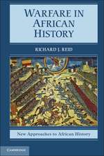 Warfare in African HistoryRichard J. ReidPreț: 200.61 lei
 -
 Preț: 242.16 lei
 -
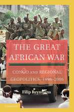 The Great African War: Congo and Regional Geopolitics, 1996–2006Filip ReyntjensPreț: 208.69 lei
 -
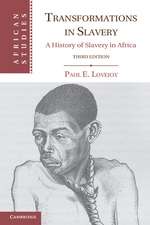 Transformations in Slavery: A History of Slavery in AfricaPaul E. LovejoyPreț: 204.11 lei
 -
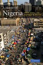 A History of NigeriaToyin FalolaPreț: 201.23 lei
 -
 A Concise History of South AfricaRobert RossPreț: 157.71 lei
 -
 -14%Preț: 169.88 lei198.18 lei
 -
 -19%Preț: 555.31 lei685.57 lei
 -
 Historical Memory in AfricaMamadou Diawara-23%Preț: 750.20 lei974.28 lei
Cuprins
Introduction; 1. Directions for sailing to the Madeiras; 2. Directions through the Canaries; 3. On the winds and calms peculiar to the Canaries; 4. Coast of Africa from Cape Spartel to Cape Bogador; 5. Description of the coast from Cape Bogador to Cape Verde; 6. Cape Verde, or Salt Islands; 7. General observations; 8. Description of the coast from Cape Verde to Cape Roxo; 9. Cape St. Mary to Roxo; 10. From Cape Roxo to Sierra Leon, including the Rio Grande, its shoals, and the Isles de Loss; 11. Mode of traffic from Grand Bassa to Cape Palmas; 12. Description of the coast from Sierra Leon to Cape Mount; 13. Sailing directions for the River Sherbro; 14. The windward coast; 15. From Cape Mount to the River St. John; 16. On the system of traffic, or barter, pursued between Cape Mount and Grand Bassa; 17. Description of the coast from Grand Bassa to Cape Palmas; 18. Description of the coast from Cape Palmas to Cape Lahou; 19. On the trade of Cape Palmas and Cape Lahou; 20. Description of the Adou or Quaqua Coast, from Cape Lahou to Assinee; 21. Description of the coast from Assinee to Cape St. Paul's; 22. Description of the mode of traffic, employed from Cape Lahou to Cape St. Paul's; 23. Description of the coast from Cape St. Paul's to Cape Formoso, constituting what is called the Bight of Benin; 24. Mode of barter of Benin; 25. Description of the coast from Cape Formosa to Cameroon's River in the Bight of Biaffra; 26. Directions for sailing into Old Callebar; 27. On the system of the Callebar trade; 28. From Callebar to Cameroon's River; 29. On the Cameroon's trade; 30. Description of the islands in the Bight of Biaffra, namely: Fernandepo, Princes, St. Thomas, and Anno Bom; 31. Description of the coast from Cameroons to Cape St. John, and from thence to Cape Lopez, including the Rivers Gabon and Danger; 32. Description of the coast from Cape Lopez to the Congo; 33. Description of the Congo; 34. Description of the coast from Cape Padron to Loando St. Paul; 35. Description of the Cape of Good Hope, with its adjacent bays; 36. The island of St. Helena; 37. The island of Ascension; 38. Of the passages to and from the coast of Africa, etc.; 39. On the homeward passage.
Descriere
An 1822 guide by a Royal Navy officer detailing how to sail to West Africa and engage in trade there.