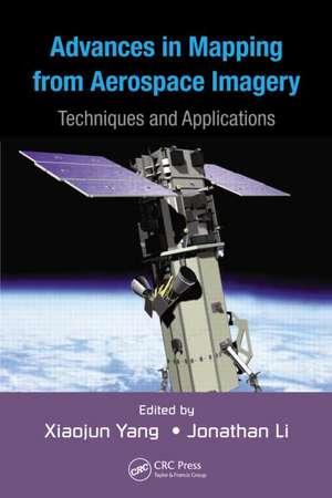
Advances in Mapping from Remote Sensor Imagery: Techniques and Applications
Editat de Xiaojun Yang, Jonathan Lien Limba Engleză Hardback – 12 dec 2012
The book covers a broad range of topics including photogrammetric mapping and LiDAR remote sensing for generating high quality topographic products, global digital elevation models, current methods for shoreline mapping, and the identification and classification of residential buildings. Contributors also showcase cutting-edge developments for environmental and ecological mapping, including assessment of urbanization patterns, mapping vegetation cover, monitoring invasive species, and mapping marine oil spills—crucial for monitoring this significant environmental hazard.
The authors exemplify the information presented in this text with case studies from around the world. Examples include:
- Envisat/ERS-2 images used to generate digital elevation models over northern Alaska
- In situ radiometric observations and MERIS images employed to retrieve chlorophyll a concentration in inland waters in Australia
- ERS-1/2 SAR images utilized to map spatiotemporal deformation in the southwestern United States
| Toate formatele și edițiile | Preț | Express |
|---|---|---|
| Paperback (1) | 435.46 lei 6-8 săpt. | |
| CRC Press – 27 oct 2017 | 435.46 lei 6-8 săpt. | |
| Hardback (1) | 1104.33 lei 6-8 săpt. | |
| CRC Press – 12 dec 2012 | 1104.33 lei 6-8 săpt. |
Preț: 1104.33 lei
Preț vechi: 1558.54 lei
-29% Nou
Puncte Express: 1656
Preț estimativ în valută:
211.31€ • 221.22$ • 174.85£
211.31€ • 221.22$ • 174.85£
Carte tipărită la comandă
Livrare economică 05-19 aprilie
Preluare comenzi: 021 569.72.76
Specificații
ISBN-13: 9781439874585
ISBN-10: 1439874581
Pagini: 464
Ilustrații: 121 b/w images, 36 tables and Less than 100
Dimensiuni: 156 x 234 x 30 mm
Greutate: 0.79 kg
Ediția:New.
Editura: CRC Press
Colecția CRC Press
Locul publicării:Boca Raton, United States
ISBN-10: 1439874581
Pagini: 464
Ilustrații: 121 b/w images, 36 tables and Less than 100
Dimensiuni: 156 x 234 x 30 mm
Greutate: 0.79 kg
Ediția:New.
Editura: CRC Press
Colecția CRC Press
Locul publicării:Boca Raton, United States
Public țintă
Undergraduate and graduate students, researchers, and professionals working in remote sensing, photogrammetry, geographic information systems, geography, and environmental science.Cuprins
Modern photogrammetric mapping. Airborne LiDAR remote sensing and its applications. Advanced algorithms for land use and cover classification. Global digital elevation model development from satellite remote-sensing data. Digital elevation model generation from satellite interferometric synthetic aperture radar. Shoreline mapping. Seeing residential buildings from remotely sensed imagery: An object-oriented approach. Assessment of urbanization patterns and trends in the Gulf of Mexico region of the southeast United States with Landsat and nighttime lights imagery. Fractional vegetation cover mapping from the HJ-1 small satellite hyperspectral data. Estimating and mapping forest leaf area index using satellite imagery. Effects of the spatial pattern of vegetation cover on urban warming in a desert city. Remote sensing of algal blooms in inland waters using the matrix inversion method and semiempirical algorithms. Advanced geospatial techniques for mapping and monitoring invasive species. Surface deformation mapping with persistent scatterer radar interferometry. Mapping marine oil spills from space. Remote-sensing techniques for natural disaster impact assessment.
Notă biografică
Xiaojun Yang is a tenured faculty member with the Department of Geography at Florida State University, USA. His research focuses on the development of geospatial science and technology to support geographic inquiries in urban and environmental domains. Dr. Yang has performed research for NASA and received grants from the NSF and EPA. He has authored or coauthored more than 80 English publications, including five books with John Wiley, Springer, and CRC/Taylor & Francis.
Dr. Yang has served as a guest editor for several peer-reviewed journals including Photogrammetric Engineering and Remote Sensing, ISPRS Journal of Photogrammetry and Remote Sensing, International Journal of Remote Sensing, Computers, Environment and Urban Systems, and Environmental Management. He currently serves the second term as chair of the International Cartographic Association (ICA) Commission on Mapping from Remote Sensor Imagery (2011–2015) and director of the Cartography and Geographic Information Society (2012–2015).
Jonathan Li is professor of geomatics at the University of Waterloo in Canada. His research interests include remote sensing, mobile mapping, and geographic information systems. Dr. Li has authored more than 190 publications, including five books with Springer and Taylor & Francis. He is vice chair of the International Cartographic Association (ICA) Commission on Mapping from Remote Sensor Imagery (2011-2015), chair of the ISPRS Inter-Commission Working Group V/I on Land-Based Mobile Mapping Systems (2008-2012), and vice chair of the International Federation of Surveyors (FIG) Commission 4 on Hydrography (2011-2014).
Descriere
This book discusses recent advances in remote sensing techniques for topographic and thematic mapping applications. The text covers modern photogrammetry, LiDAR remote sensing, and advanced image classification techniques; the use of remote sensing and image-processing techniques for extracting geographic features needed for topographic map production; and the synergistic use of remote sensing and image-processing techniques for environmental and ecological mapping. This book provides a state-of-the-art review for researchers and students working in remote sensing, photogrammetry, geographic information systems, geography, and environmental science.
