Multi-sensor System Applications in the Everglades Ecosystem: Remote Sensing Applications Series
Autor Caiyun Zhangen Limba Engleză Paperback – 21 ian 2023
Features
- Introduces concepts, theories, and advanced processing techniques
- A complete introduction of machine learning, object-based image analysis, data fusion, and ensemble analysis techniques in processing data from multiple remote sensors
- Explains how multiple remote sensing systems are applied in the wetland ecosystems of Florida
- The author had been teaching and using both systems and her research is widely recognized
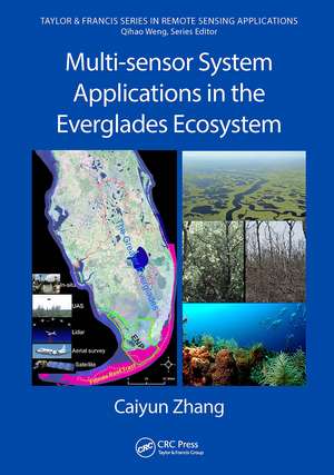
Multi-sensor System Applications in the Everglades Ecosystems provides a comprehensive application of remote sensing techniques in the Florida Everglades and its coastal ecosystems. It will prove an invaluable resource for the restoration and conservation of the Florida Everglades and beyond, for global wetlands in general. Any professional, scientist, engineer, or student working with remote sensing and wetland ecosystems will reap enormous benefits from this book.
| Toate formatele și edițiile | Preț | Express |
|---|---|---|
| Paperback (1) | 310.54 lei 6-8 săpt. | |
| CRC Press – 21 ian 2023 | 310.54 lei 6-8 săpt. | |
| Hardback (1) | 777.67 lei 6-8 săpt. | |
| CRC Press – 14 ian 2020 | 777.67 lei 6-8 săpt. |
Din seria Remote Sensing Applications Series
- 8%
 Preț: 506.11 lei
 - 9%
 Preț: 614.37 lei
 - 15%
 Preț: 501.05 lei
 - 16%
 Preț: 337.84 lei
 - 21%
 Preț: 381.74 lei
 - 28%
 Preț: 992.21 lei
 - 25%
 Preț: 1058.86 lei
 - 26%
 Preț: 434.61 lei
 - 12%
 Preț: 314.66 lei
 - 15%
 Preț: 489.26 lei
 - 13%
 Preț: 336.54 lei
 - 25%
 Preț: 485.78 lei
 - 26%
 Preț: 368.57 lei
 -
 Preț: 446.17 lei
 - 15%
 Preț: 574.85 lei
 - 15%
 Preț: 641.32 lei
 - 15%
 Preț: 494.99 lei
 - 31%
 Preț: 928.98 lei
Preț: 310.54 lei
Preț vechi: 362.20 lei
-14% Nou
Puncte Express: 466
Preț estimativ în valută:
59.42€ • 62.05$ • 49.07£
59.42€ • 62.05$ • 49.07£
Carte tipărită la comandă
Livrare economică 15-29 aprilie
Preluare comenzi: 021 569.72.76
Specificații
ISBN-13: 9781032474878
ISBN-10: 1032474874
Pagini: 358
Ilustrații: 170
Dimensiuni: 178 x 254 mm
Greutate: 0.98 kg
Ediția:1
Editura: CRC Press
Colecția CRC Press
Seria Remote Sensing Applications Series
ISBN-10: 1032474874
Pagini: 358
Ilustrații: 170
Dimensiuni: 178 x 254 mm
Greutate: 0.98 kg
Ediția:1
Editura: CRC Press
Colecția CRC Press
Seria Remote Sensing Applications Series
Public țintă
Professional Practice & DevelopmentCuprins
Part I. Florida Everglades and Remote Sensing. 1. Florida Everglades and Restoration. 2. Introduction to Remote Sensing. 3. Vegetation Classification System in the Everglades. Part II. 4. Applying Aerial Photography to Map Marsh Species in the Wetland of Lake Okeechobee. 5. Unmanned Aircraft System (UAS) for Wetland Species Mapping. 6. Spaceborne Multispectral Sensors for Vegetation Mapping and Change Analysis. 7. Water Quality Modeling and Mapping using Landsat Data. 8. Mapping Sawgrass Aboveground Biomass using Landsat Data. 9. Applying Landsat Products to Assess the Damage and Resilience of Mangroves from Hurricanes. Part III. Hyperspectral Remote Sensing Applications 10. Applying Point Spectroscopy Data to Assess the Effects of Salinity and Sea Level Rise on Canopy Water Content of Juncus roemaerianus. 11. Applying Point Spectroscopy Data to Characterize Sand Properties. 12. Land Cover-level Vegetation Mapping using AVIRIS. 13. Species-level Vegetation Mapping in the Kissimmee River Floodplain using HyMap Data. 14. Benthic Habitat Mapping in the Florida Keys using EO-1/Hyperion. Part IV. Lidar Remote Sensing Applications. 15. Vulnerability Analysis of Coastal Everglades to Sea Level Rise using SLAMM. 16. Enhancing Lidar Data Integrity in the Coastal Everglades. 17. Assessing the Effects of Hurricane Irma on Mangrove Structures in the Coastal Everglades using Airborne Lidar Data. Part V. Fusing Multiple Sensors for Everglades Applications. 18. Integrating Aerial Photography, EO-1/Hyperion, and Lidar Data to Map Vegetation in the Coastal Everglades. 19. Assessing a Multi-sensor Fusion Approach to Map Detailed Reef Benthic Habitats in the Florida Reef Tract. Index.
Notă biografică
Dr. Zhang received her Ph.D. in Geospatial Information Sciences from University of Texas, Dallas. Her research at FAU focuses on vegetation characterization in the Florida Everglades using multiple sensors, biomass modeling and mapping, water quality monitoring and mapping, and analyzing coastal vulnerability to sea level rise and hurricanes. She has developed innovative methodology frameworks to monitor and map the Greater Everglades by combining multiple sensors and GIS techniques, which can assist with the restoration and conservation of the Florida Everglades ecosystem. She applies modern machine learning and advanced remote sensing image processing techniques in the coastal environments to understand the effects of human activities and natural disasters on the modification of coastal landscapes. She is teaching five major remote sensing courses at FAU including Remote Sensing of Environment, Digital Image Analysis, Hyperspectral Remote Sensing, Lidar Remote Sensing and Applications, and Photogrammetry and Aerial Photo Interpretation.
Descriere
This book introduces multiple remote sensing systems, advanced data processing techniques, and applications of multiple remote sensing systems in wetland environments, especially Florida. The application of the systems' datasets, especially LiDAR data, applied to wetland ecosystems is unique from other case studies.