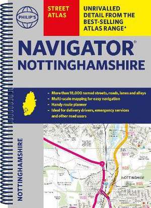
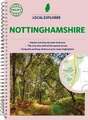
Philip's Navigator Street Atlas Nottinghamshire: Philip's Street Atlas
Autor Philip's Mapsen Limba Engleză Paperback – 4 oct 2023
Din seria Philip's Street Atlas
- 23%
 Preț: 74.24 lei
 - 21%
 Preț: 87.03 lei
 - 23%
 Preț: 74.29 lei
 - 21%
 Preț: 86.95 lei
 - 22%
 Preț: 86.75 lei
 - 23%
 Preț: 74.29 lei
 - 21%
 Preț: 86.95 lei
 - 23%
 Preț: 74.22 lei
 - 21%
 Preț: 87.19 lei
 - 22%
 Preț: 86.82 lei
 - 22%
 Preț: 86.13 lei
 - 22%
 Preț: 86.06 lei
 - 21%
 Preț: 87.42 lei
 - 21%
 Preț: 87.35 lei
 - 23%
 Preț: 83.54 lei
 - 23%
 Preț: 83.58 lei
 - 21%
 Preț: 88.75 lei
 - 22%
 Preț: 85.85 lei
 - 22%
 Preț: 86.67 lei
 - 22%
 Preț: 85.90 lei
 - 21%
 Preț: 88.71 lei
 - 23%
 Preț: 84.51 lei
 - 21%
 Preț: 88.71 lei
 - 23%
 Preț: 84.64 lei
 -
 Preț: 63.29 lei
 - 31%
 Preț: 30.72 lei
 - 33%
 Preț: 44.88 lei
Preț: 86.48 lei
Preț vechi: 110.41 lei
-22% Nou
16.55€ • 17.99$ • 13.91£
Carte disponibilă
Livrare economică 31 martie-14 aprilie
Livrare express 14-20 martie pentru 58.12 lei
Specificații
ISBN-10: 1849076413
Pagini: 272
Dimensiuni: 194 x 266 x 14 mm
Greutate: 0.59 kg
Editura: OCTOPUS PUBLISHING GROUP
Colecția Philip's Street Atlas
Seria Philip's Street Atlas
Notă biografică
Philip's has been at the forefront of creating maps and atlases since 1834. Whether a local street map or a fact-packed World Atlas, we use the most up-to-date technology, expertise and our global network to ensure our customers have all the information they need.
Descriere
The only county Street Atlas with all the named streets of Nottinghamshire and perfect back-up for emergency services, delivery drivers, visitors and locals.
With more than 18,000 named streets, roads, lanes and alleys, this is the essential map book for residents and visitors - especially if you're in a hurry
Includes all the streets in BEESTON, MANSFIELD, NOTTINGHAM, SUTTON IN ASHFIELD, WEST BRIDGFORD, WORKSOP, Balderton, Bawtry, Bingham, Blidworth, Bottesford, Calverton, Clifton, Cotgrave, East Leake, Eastwood, Edwinstowe, Gainsborough, Harworth, Hucknall, Kegworth, Keyworth, Kimberley, Kirkby in Ashfield, Long Eaton, Mansfield Woodhouse, Market Warsop, Newark-on-Trent, Ollerton, Pinxton, Radcliffe on Trent, Rainworth, Ravenshead, Retford, Ruddington, Saxilby, Shirebrook, Southwell, Stapleford, Tickwell.
- New completely revised edition in practical spiral-bound format
- Street maps show car parks, schools, hospitals and many other places of interest, including off the beaten track
- 4-page practical route-planning section showing all A and B roads
- Super-clear mapping
- Easy-to-use index
- Scales: 13/4 inches to 1 mile (1:36,000) and 31/2 inches to 1 mile (1:18,000). Major towns: 7 inches to 1 mile (1:9,000).
Other information on the maps includes postcode boundaries, car parks, railway and bus stations, post offices, schools, colleges, hospitals, police and fire stations, places of worship, leisure centres, footpaths and bridleways, camping and caravan sites, golf courses, and many other places of interest.