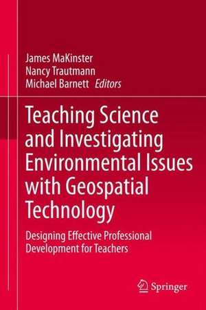
Teaching Science and Investigating Environmental Issues with Geospatial Technology: Designing Effective Professional Development for Teachers
Editat de James MaKinster, Nancy Trautmann, Michael Barnetten Limba Engleză Hardback – 19 noi 2013
The first half of this book will enable science and environmental educators to share the nature and structure of large scale professional development projects while discussing the theoretical commitments that undergird their work. Many chapters will include temporal aspects that present the ways in which projects change over time in response to evaluative research and practical experience.
In the second half of the book, faculty and others whose focus is on national and international scales will share the ways in which they are working to meet the growing needs of teachers across the globe to incorporate geospatial technology into their science teaching. These efforts reflect the ongoing conversations in science education, geography, and the geospatial industry in ways that embody the opportunities and challenges inherent to this field.
This edited book will serve to define the field of teacher professional development for teaching science using geospatial technology. As such, it will identify short term and long term objectives for science, environmental, and geography educators involved in these efforts. As a result, this book will provide a framework for future projects and research in this exciting and growing field.
| Toate formatele și edițiile | Preț | Express |
|---|---|---|
| Paperback (1) | 643.84 lei 6-8 săpt. | |
| SPRINGER NETHERLANDS – 23 aug 2016 | 643.84 lei 6-8 săpt. | |
| Hardback (1) | 650.19 lei 6-8 săpt. | |
| SPRINGER NETHERLANDS – 19 noi 2013 | 650.19 lei 6-8 săpt. |
Preț: 650.19 lei
Preț vechi: 764.93 lei
-15% Nou
Puncte Express: 975
Preț estimativ în valută:
124.41€ • 129.91$ • 102.74£
124.41€ • 129.91$ • 102.74£
Carte tipărită la comandă
Livrare economică 16-30 aprilie
Preluare comenzi: 021 569.72.76
Specificații
ISBN-13: 9789048139309
ISBN-10: 9048139309
Pagini: 325
Ilustrații: XI, 353 p. 46 illus.
Dimensiuni: 155 x 235 x 27 mm
Greutate: 0.69 kg
Ediția:2014
Editura: SPRINGER NETHERLANDS
Colecția Springer
Locul publicării:Dordrecht, Netherlands
ISBN-10: 9048139309
Pagini: 325
Ilustrații: XI, 353 p. 46 illus.
Dimensiuni: 155 x 235 x 27 mm
Greutate: 0.69 kg
Ediția:2014
Editura: SPRINGER NETHERLANDS
Colecția Springer
Locul publicării:Dordrecht, Netherlands
Public țintă
ResearchCuprins
Introduction.- Participatory Professional Development: Geospatially Enhanced Urban Ecological Field Studies.- Field-based Research Partnerships: Teachers, Students, and Scientists Investigate the Geologic History of Eastern Montana Using Geospatial Technologies.- The GIT Ahead Project: Meeting Teachers Where They Are and Helping Them Achieve Their Geospatial Goals.- Spatial Sci: Forwarding Geospatial Technology Innovations In the Classroom.- Eyes in the Sky: Facilitating Classroom Research Using Geospatial Technology.- Coastlines: Commitment, Comfort, Competence, Empowerment, and Relevance in Professional Development.- The Inquiring with GIS (iGIS) Project: Helping Teachers Create and Lead Local GIS-Based Investigations.-
Communities for Rural Education, Stewardship and Technology Program (CREST): A Rural Model of Teacher Professional Development.- Curriculum Aligned Professional Development for Geospatial Education.- Impact of Science Teacher Professional Development through Geospatial Technologies: A 5-Step Program of Support.- The Data Sets and Inquiry in Geoscience Education Project: A Model Curricula for Teacher Capacity Building in Scientific Inquiry Tasks With Geospatial Data.- Designing Google Earth Activities for Learning Earth and Environmental Science.-
Designing Geospatial Exploration Activities to Build Environmental Awareness in Middle School Students.- The Lonely Trailblazers: Examining the Early Implementation of Geospatial Technologies in Science Classrooms.- Understanding the Use of Geospatial Technologies to Teach Science: TPACK as a Lens for Effective Teaching.- Moving Out of Flatland: Toward Effective Practice in Geospatial Inquiry.- What Happens After Professional Development: Case Studies on Implementing GIS in the Classroom.- The Nature and Design of Professional Development for Using Geospatial Technologies to Teach Science.- The Nature of Teacher Knowledge Necessary for the Effective Use of Geospatial Technologies to Teach Science.
Textul de pe ultima copertă
This book provides research-grounded and practically-minded insights into teacher professional development in support of integrating GIS and other geospatial technologies into K-12 science teaching. In this volume 50 designers, educators and researchers share their experiences, knowledge, and lessons learned from a wide variety of projects. Readers will find a myriad of ideas and perspectives that they can apply to their own teacher professional development projects, as they work to provide students with engaging opportunities for learning science.
Geospatial technologies enable teachers to teach in fundamentally new ways, building student interest and skill through active engagement in critical thinking and project or inquiry-based learning. Students are naturally drawn to looking at landscapes and interpreting features through analysis of both shape and form. Given the chance to manipulate spatial data, students revel in deciphering mysteries, exploring scientific explanations, and linking causes with consequences.
The passion and interest demonstrated by students using geospatial tools has motivated an increasing number of K-12 teachers to embrace the use of these technologies for teaching and learning science. Given the nature and complexity of these tools, high quality professional development is essential for providing teachers with the support and guidance they need to use geospatial technologies effectively.
This book will be of special interest to scientists, geographers, and science educators who are designing or delivering teacher professional development in support of teaching with technology. The case studies make it possible for readers to identify specific paths forward regarding both research and practice.
GIS and other geospatial technologies offer teachers an effective way to engage students in the analysis of authentic data in ways called for by the Next Generation Science Standards and the National GeographyStandards. With the improvements in the usability of the tools, the time is right to bring GIS and other geospatial technologies into all K-12 classrooms. The chapters in this book will enable teachers and teacher educators to make that happen.
Daniel C. Edelson, Ph.D., Vice President for Education, National Geographic Society
While increasing numbers of people use basic geospatial technologies, their power to enliven science has not yet been explored by most educators. This robust and thoughtful compilation focuses on how to support teachers as they introduce and implement these technologies in their classes. It examines curricular, philosophical, pedagogical, and professional development considerations through an array of real-world projects. Of particular interest are explanations of how programs were tailored to meet the varied needs of participating teachers and their students. I encourage educators who work with pre-service or in-service science, environmental science, social studies, or geography teachers to build their efforts based on the insights accumulated in this collection.
Christine M. Cunningham, Ph.D., Vice President, Museum of Science, Boston
This is the finest collection of professional development wisdom from thought leaders across 20 years of GIS and science education. It's a must read for educators, researchers, and curriculum developers interested in emerging educational technologies.
Tom Baker, ESRI
Caracteristici
Defines the field of teacher professional development for teaching science using geospatial technology Describes the design and outcomes of specific teacher professional development strategies and relates these to lessons learned Provides insights into best practices for preparing teachers to use geospatial technology as they engage students in projects that build skills in data analysis, problem solving, and spatial thinking
