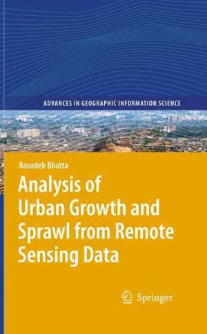
Analysis of Urban Growth and Sprawl from Remote Sensing Data: Advances in Geographic Information Science
Autor Basudeb Bhattaen Limba Engleză Paperback – 4 mai 2012
This book will be of value for the scientists and researchers engaged in urban geographic research, especially using remote sensing imageries. This book will serve as a rigours literature review for them. Post graduate students of urban geography or urban/regional planning may refer this book as additional studies. This book may help the academicians for preparing lecture notes and delivering lectures. Industry professionals may also be benefited from the discussed methods and models along with numerous citations.
| Toate formatele și edițiile | Preț | Express |
|---|---|---|
| Paperback (1) | 635.96 lei 6-8 săpt. | |
| Springer Berlin, Heidelberg – 4 mai 2012 | 635.96 lei 6-8 săpt. | |
| Hardback (1) | 641.71 lei 6-8 săpt. | |
| Springer Berlin, Heidelberg – 11 mar 2010 | 641.71 lei 6-8 săpt. |
Din seria Advances in Geographic Information Science
- 18%
 Preț: 1110.72 lei
 - 24%
 Preț: 669.66 lei
 - 24%
 Preț: 606.73 lei
 - 15%
 Preț: 637.46 lei
 - 18%
 Preț: 899.21 lei
 - 18%
 Preț: 1388.68 lei
 - 18%
 Preț: 948.92 lei
 - 15%
 Preț: 635.15 lei
 - 18%
 Preț: 944.67 lei
 - 18%
 Preț: 954.31 lei
 - 15%
 Preț: 641.71 lei
 - 15%
 Preț: 646.11 lei
 - 18%
 Preț: 1118.75 lei
 - 15%
 Preț: 648.56 lei
 - 18%
 Preț: 1230.84 lei
 - 18%
 Preț: 948.29 lei
 - 18%
 Preț: 1123.19 lei
 - 18%
 Preț: 948.47 lei
 - 18%
 Preț: 956.69 lei
 - 18%
 Preț: 941.82 lei
 - 15%
 Preț: 635.80 lei
 - 18%
 Preț: 761.72 lei
 - 18%
 Preț: 894.03 lei
Preț: 635.96 lei
Preț vechi: 748.20 lei
-15% Nou
Puncte Express: 954
Preț estimativ în valută:
121.71€ • 126.59$ • 100.48£
121.71€ • 126.59$ • 100.48£
Carte tipărită la comandă
Livrare economică 14-28 aprilie
Preluare comenzi: 021 569.72.76
Specificații
ISBN-13: 9783642262876
ISBN-10: 3642262872
Pagini: 192
Ilustrații: XX, 172 p.
Dimensiuni: 155 x 235 x 10 mm
Greutate: 0.3 kg
Ediția:2010
Editura: Springer Berlin, Heidelberg
Colecția Springer
Seria Advances in Geographic Information Science
Locul publicării:Berlin, Heidelberg, Germany
ISBN-10: 3642262872
Pagini: 192
Ilustrații: XX, 172 p.
Dimensiuni: 155 x 235 x 10 mm
Greutate: 0.3 kg
Ediția:2010
Editura: Springer Berlin, Heidelberg
Colecția Springer
Seria Advances in Geographic Information Science
Locul publicării:Berlin, Heidelberg, Germany
Public țintă
ResearchCuprins
Urban Growth and Sprawl.- Causes and Consequences of Urban Growth and Sprawl.- Towards Sustainable Development and Smart Growth.- Remote Sensing, GIS, and Urban Analysis.- Mapping and Monitoring Urban Growth.- Measurement and Analysis of Urban Growth.- Modelling and Simulation of Urban Growth.- Limitations of Urban Growth Analysis.
Notă biografică
The author is currently a Course Coordinator in the Computer Aided Design Centre of Jadavpur University, Kolkata. He has more than 13 years of industrial, teaching and research experience in remote sensing, GNSS, and GIS. He has authored numerous research papers and articles in various journals and magazines. He has also authored two textbooks on Remote Sensing, GNSS, and GIS. In recent years he has been engaged with rigorous research on applications of geoinformatics in urban geographic studies
Textul de pe ultima copertă
This book provides a comprehensive discussion on urban growth and sprawl, and how they can be analyzed using remote sensing imageries. It compiles the views of numerous researchers which help in understanding urban growth and sprawl; their patterns, process, causes, consequences, and countermeasures; how remote sensing data and geographic information system techniques can be used in mapping, monitoring, measuring, analyzing, and simulating the urban growth and sprawl; and the merits and demerits of current methods and models.
Scientists and researchers engaged in urban geographic research will benefit greatly from this book, especially when using remote sensing imageries. Post graduate students of urban geography or urban/regional planning may refer to this book for additional information. This book should also assist academicians when preparing lecture notes and delivering lectures. Professionals in related fields in industry will appreciate the methods and models discussed as well as the many citations.
Scientists and researchers engaged in urban geographic research will benefit greatly from this book, especially when using remote sensing imageries. Post graduate students of urban geography or urban/regional planning may refer to this book for additional information. This book should also assist academicians when preparing lecture notes and delivering lectures. Professionals in related fields in industry will appreciate the methods and models discussed as well as the many citations.
Caracteristici
Includes supplementary material: sn.pub/extras


