GIS Applications in Agriculture, Volume Three: Invasive Species: GIS Applications in Agriculture
Editat de Sharon A. Clayen Limba Engleză Paperback – 19 sep 2019
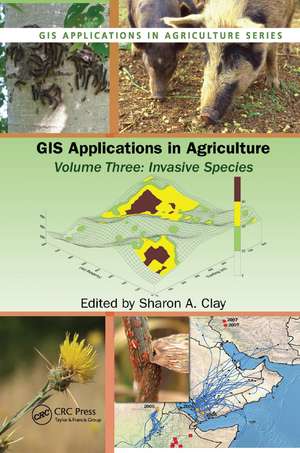
Beginning with an introduction to the use of GIS technology to capture, store, analyze, manage, and present data, GIS Applications in Agriculture, Volume Three: Invasive Species examines five relevant categories of geographic information including dispersal and transport, prediction and forecasting, mapping of current infestations, maps for management and control tactics, and impact assessment and method of control. It address GIS for studying the population ecology of a new species, niche requirements for species success, and the monitoring and control of several different species including Australian examples of intentionally introduced invasive species, insects and other animals that may also vector a disease, and invasive weed management from prediction to management.
Chapters cover maps and imageries available on various Web sites and provide step-by-step tutorials or case studies that allow manipulation of datasets featured on the accompanyingdownloadable resources to make maps, perform statistical analyses, and predict future problems. It offers hands-on experience with a variety of software programs that create interactive queries (user-created searches), analyze spatial information, edit data and maps, and present the results of these operations in several different formats. Some of the programs are freeware, others are not, but each can be used to integrate, edit, share, and display geographic information. Color figures are
| Toate formatele și edițiile | Preț | Express |
|---|---|---|
| Paperback (1) | 496.62 lei 6-8 săpt. | |
| CRC Press – 19 sep 2019 | 496.62 lei 6-8 săpt. | |
| Hardback (1) | 1284.38 lei 6-8 săpt. | |
| CRC Press – 16 feb 2011 | 1284.38 lei 6-8 săpt. |
Preț: 496.62 lei
Preț vechi: 584.25 lei
-15% Nou
Puncte Express: 745
Preț estimativ în valută:
95.06€ • 103.29$ • 79.90£
95.06€ • 103.29$ • 79.90£
Carte tipărită la comandă
Livrare economică 21 aprilie-05 mai
Preluare comenzi: 021 569.72.76
Specificații
ISBN-13: 9780367383053
ISBN-10: 0367383055
Pagini: 448
Dimensiuni: 156 x 234 x 23 mm
Greutate: 0.66 kg
Ediția:1
Editura: CRC Press
Colecția CRC Press
Seria GIS Applications in Agriculture
ISBN-10: 0367383055
Pagini: 448
Dimensiuni: 156 x 234 x 23 mm
Greutate: 0.66 kg
Ediția:1
Editura: CRC Press
Colecția CRC Press
Seria GIS Applications in Agriculture
V-ar putea interesa
-
 Geopolitics of the Pakistan–Afghanistan BorderlandSyed Sami Raza-18%Preț: 1004.55 lei1225.06 lei
 -
 Preț: 389.99 lei
 -
 The Economics of Urban Property Markets: An Institutional Economics AnalysisPaschalis ArvanitidisPreț: 303.89 lei
 -
 Environmental PublicsSally Eden-15%Preț: 309.60 lei362.74 lei
 -
 -12%Preț: 299.52 lei341.57 lei
 -
 La Faim et la Sant?: Collection: La Faim dans le Monde (2007)World Food Programme-28%Preț: 986.91 lei1366.55 lei
 -
 Preț: 108.15 lei
 -
 Preț: 94.62 lei
 -
 Preț: 130.65 lei
 -
 Preț: 94.23 lei
 -
 Preț: 168.88 lei
 -
 Preț: 107.95 lei
 -
 Preț: 169.09 lei
 -
 Preț: 192.33 lei
 -
 Preț: 80.08 lei
 -
 Preț: 238.79 lei
 -
 Preț: 207.15 lei
 -
 Preț: 254.05 lei
 -
 Preț: 192.33 lei
 -
 Preț: 268.32 lei
 -
 Preț: 79.16 lei
 -
 Preț: 108.92 lei
 -
 Preț: 123.02 lei
 -
 Preț: 108.54 lei
 -
 Preț: 138.31 lei
 -
 Preț: 200.34 lei
Public țintă
Academic and Professional ReferenceCuprins
Introduction: Remote Sensing and GIS Techniques for the Detection, Surveillance, and Management of Invasive Species. Obtaining Spatial Data. Population Ecology Considerations for Monitoring and Managing Biological Invasions. Integrating GPS, GIS, and Remote Sensing Technologies with Disease Management Principles to Improve Plant Health. Mapping Actual and Predicted Distribution of Pest Animals and Weeds in Australia. Use of GIS Applications to Combat the Threat of Emerging Virulent Wheat Stem Rust Races. An Online Aerobiology Process Model. Site Specific Management of Green Peach Aphid, Myzus persicae (Sulzer). Analysis of the 2002 Equine West Nile Virus Outbreak in South Dakota Using GIS and Spatial Statistics. Designing a Local-scale Microsimulation of Lesser Grain Borer Population Dynamics and Movements. Geographic Information Systems in Corn Rootworm Management,. Improving Surveillance for Invasive Plants: A GIS Toolbox for Surveillance Decision Support. Tracking Invasive Weed Species in Rangeland Using Probability Functions to Identify Site Specific Boundaries: A Case Study Using Yellow Starthistle (Centaurea solstitialis L.). Using GIS to Map and Manage Weeds in Field Crops. Adapting Geostatistics to Analyze Spatial and Temporal Trends in Weed Populations. Using GIS to Investigate Weed Shifts After Two Cycles of a Corn/Soybean Rotation. Creating and Using Weed Maps for Site-Specific Management.
Notă biografică
The Editor:
Sharon A. Clay, PhD., is a professor of weed science at South Dakota State University where she has research and teaching responsibilities. She received a B.S. degree in Horticulture from the University of Wisconsin-Madison in 1977, an M.S. degree in Plant Science from the University of Idaho in 1983 examining barley variety sensitivity to various herbicides, and a Ph.D. in Agronomy from the University of Minnesota in 1987 where she examined weed management in wild rice production systems of northern Minnesota.
She has conducted weed management studies in range and cropping systems that include corn, soybean, wheat, barley, wild rice, flax, and sunflower, as well as studies in weed physiology and site specific weed management strategies. Dr. Clay has published over 100 scientific articles and has served on the editorial boards for Agronomy Journal, Weed Science, and Site-Specific Management Guidelines. Dr. Clay has served on numerous national committees and review panels and has active memberships in, and has served as president of the SD Chapters of the honorary societies Sigma Xi and Gamma Sigma Delta. She served as the chairperson of the Agricultural Systems division in the American Society of Agronomy, participated in numerous ASA committees, was elected to ASA Fellow in 2009, and has held several positions in the Weed Science Society of America.
Descriere
This volume focuses on GIS applications in the fight against invasive species, including weeds, insects, disease, and microbes. It offers practical applications for mapping and managing invasives and presents research on GIS applications in monitoring, tracking, modeling, forecasting, and managing, as well as assessing for economic and environme