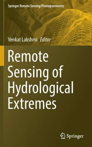
Remote Sensing of Hydrological Extremes: Springer Remote Sensing/Photogrammetry
Editat de Venkat Lakshmien Limba Engleză Hardback – 16 dec 2016
This volume provides in-depth coverage of the latest in remote sensing of hydrological extremes: both floods and droughts. The book is divided into two distinct sections – floods and droughts – and offers a variety of techniques for monitoring each.
We are at a critical juncture in the study of hydrological extremes, and the GPM and SMAP missions as well as the MODIS and GRACE sensors give us more tools and data than were ever available before. A global variety of chapter authors provides wide-ranging perspectives and case studies that will make this book an indispensable resource for researchers, engineers, and even emergency management and insurance professionals who study and/or manage hydrological extremes.
| Toate formatele și edițiile | Preț | Express |
|---|---|---|
| Paperback (1) | 725.43 lei 6-8 săpt. | |
| Springer International Publishing – 4 iul 2018 | 725.43 lei 6-8 săpt. | |
| Hardback (1) | 1112.60 lei 6-8 săpt. | |
| Springer International Publishing – 16 dec 2016 | 1112.60 lei 6-8 săpt. |
Din seria Springer Remote Sensing/Photogrammetry
- 15%
 Preț: 653.98 lei
 - 24%
 Preț: 847.78 lei
 - 24%
 Preț: 911.54 lei
 - 15%
 Preț: 644.18 lei
 - 24%
 Preț: 694.68 lei
 - 18%
 Preț: 785.11 lei
 - 18%
 Preț: 950.52 lei
 - 18%
 Preț: 895.58 lei
 - 18%
 Preț: 946.87 lei
 - 18%
 Preț: 1244.71 lei
 - 18%
 Preț: 1114.02 lei
 - 24%
 Preț: 728.29 lei
 - 24%
 Preț: 895.51 lei
 - 18%
 Preț: 1105.83 lei
 - 20%
 Preț: 560.05 lei
 - 18%
 Preț: 1043.14 lei
 - 18%
 Preț: 944.34 lei
 - 18%
 Preț: 888.18 lei
 - 18%
 Preț: 892.46 lei
 - 18%
 Preț: 1005.61 lei
 - 24%
 Preț: 844.06 lei
Preț: 1112.60 lei
Preț vechi: 1356.83 lei
-18% Nou
Puncte Express: 1669
Preț estimativ în valută:
212.95€ • 221.48$ • 178.45£
212.95€ • 221.48$ • 178.45£
Carte tipărită la comandă
Livrare economică 13-27 martie
Preluare comenzi: 021 569.72.76
Specificații
ISBN-13: 9783319437439
ISBN-10: 3319437437
Pagini: 330
Ilustrații: XIV, 251 p. 74 illus., 71 illus. in color.
Dimensiuni: 155 x 235 x 16 mm
Greutate: 0.55 kg
Ediția:1st ed. 2017
Editura: Springer International Publishing
Colecția Springer
Seria Springer Remote Sensing/Photogrammetry
Locul publicării:Cham, Switzerland
ISBN-10: 3319437437
Pagini: 330
Ilustrații: XIV, 251 p. 74 illus., 71 illus. in color.
Dimensiuni: 155 x 235 x 16 mm
Greutate: 0.55 kg
Ediția:1st ed. 2017
Editura: Springer International Publishing
Colecția Springer
Seria Springer Remote Sensing/Photogrammetry
Locul publicării:Cham, Switzerland
Cuprins
Part 1 Floods.- Chapter 1 Satellite-based estimation Of water discharge and runoff In the Magdalena River, Northern Andes Of Colombia.- Chapter 2 Remote sensing of drivers of spring snowmelt flooding in the North Central US.- Chapter 3 The NASA Global Flood Mapping System.- Chapter 4 Congo flood plain hydraulics with PALSAR InSAR and Envisat Altimetry data.- Chapter 5 Optical and physical methods for mapping flooding with satellite imagery.- Chapter 6 Near real time flood monitoring and impact assessment systems.- Part 2 Droughts.- Chapter 7 Remote sensing of drought: Vegetation, soil moisture and data assimilation.- Chapter 8 Drought monitoring and assessment using remote sensing.- Chapter 9 A framework for assessing soil moisture deficit, and crop water stress at multiple space and time scales under climate change scenarios using model platform, satellite remote sensing and decision support system.- Chapter 10 Monitoring drought in Brazil using remote sensing.- Chapter 11 Multi-sensor remote sensing of drought from space.
Notă biografică
Dr. Venkat Lakshmi currently serves as Cox Visiting Professor in Stanford University's Department of Geophysics. He has been a member of the Department of Earth and Ocean Sciences at the University of South Carolina since 1999 and a full Professor since 2006. Remote Sensing of Hydrological Extremes is Dr. Lakshmi's third book.
Textul de pe ultima copertă
This volume provides in-depth coverage of the latest in remote sensing of hydrological extremes: both floods and droughts. The book is divided into two distinct sections – floods and droughts – and offers a variety of techniques for monitoring each.
With rapid advances in computer modelling and observing systems, floods and droughts are studied with greater precision today than ever before. Land surface models, especially over the entire Continental United States, can map the hydrological cycle at kilometre and sub-kilometre scales. In the case of smaller areas there is even higher spatial resolution and the only limiting factor is the resolution of input data. In-situ sensors are automated and the data is directly relayed to the world wide web for many hydrological variables such as precipitation, soil moisture, surface temperature and heat fluxes. In addition, satellite remote sensing has advanced to providing twice a day repeat observationsat kilometre to ten-kilometre spatial scales.
We are at a critical juncture in the study of hydrological extremes, and the GPM and SMAP missions as well as the MODIS and GRACE sensors give us more tools and data than were ever available before. A global variety of chapter authors provides wide-ranging perspectives and case studies that will make this book an indispensable resource for researchers, engineers, and even emergency management and insurance professionals who study and/or manage hydrological extremes.
Caracteristici
Provides the latest science to support emergency management during hydrological extremes Covers very recent satellite missions including GPM and SMAP Contains chapters and case studies from a global variety of research teams Includes supplementary material: sn.pub/extras


